Steady Precipitation Preceding A Front Is An Indication Of
Onlines
Mar 19, 2025 · 6 min read
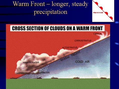
Table of Contents
Steady Precipitation Preceding a Front: An Indication of a Warm Front
Steady precipitation preceding a front is a strong indicator of a warm front. Understanding this relationship requires exploring the dynamics of warm fronts, the types of precipitation they produce, and how they differ from other frontal systems. This comprehensive guide will delve into the meteorological processes behind this phenomenon, providing valuable insights for weather enthusiasts and professionals alike.
Understanding Warm Fronts and Their Associated Precipitation
A warm front is a weather phenomenon where a warm air mass advances and overrides a cooler air mass. Unlike cold fronts, which are characterized by rapid movement and intense weather, warm fronts move more slowly, leading to a gradual and prolonged period of precipitation. The slower movement allows for a more extended period of cloud formation and precipitation development, often resulting in a steady rain or snow.
The Mechanics of Warm Front Precipitation
The key to understanding the precipitation associated with a warm front lies in the process of overrunning. As the warmer, less dense air mass rises over the colder, denser air, it cools adiabatically. This cooling leads to condensation, forming clouds and eventually precipitation. The slow ascent of the warm air allows for the development of extensive cloud layers, primarily stratus and nimbostratus clouds, which are responsible for the characteristic steady precipitation.
-
Stratus clouds: These are low-level clouds characterized by their flat and layered appearance. They often produce light to moderate precipitation, contributing to the steady nature of the rain or snow associated with warm fronts.
-
Nimbostratus clouds: These are thicker, darker clouds that are associated with more persistent and heavier precipitation. The extensive nature of these clouds over a wide area results in widespread, prolonged rainfall.
Precipitation Types Associated with Warm Fronts
The type of precipitation associated with a warm front depends largely on the temperature profile of the atmosphere.
-
Rain: In warmer regions, the precipitation will typically be rain. The steady nature of the rain, often lasting for many hours, is a key identifying feature.
-
Snow: In colder regions, or at higher altitudes, the precipitation can be snow. The steady snowfall, often accumulating over time, can lead to significant accumulations.
-
Freezing Rain/Sleet: In transitional zones where temperatures are near freezing, precipitation can fall as freezing rain or sleet. This presents a significant hazard, as freezing rain can coat surfaces with ice, leading to hazardous driving conditions.
Distinguishing Warm Front Precipitation from Other Systems
While steady precipitation is a hallmark of a warm front, it's crucial to distinguish it from other weather systems that may also produce prolonged rainfall.
Cold Fronts: Sharp Contrast
Cold fronts, unlike warm fronts, are associated with a sharp boundary between the warm and cold air masses. The passage of a cold front is often marked by a rapid increase in wind speed, a significant temperature drop, and intense, but often shorter-lived, precipitation. This precipitation is typically more showery and convective, rather than the steady, widespread rain or snow of a warm front.
Occluded Fronts: Complex Interactions
Occluded fronts form when a faster-moving cold front overtakes a slower-moving warm front. The precipitation associated with an occluded front can be quite complex and variable, depending on the characteristics of the interacting air masses. While it might feature sustained precipitation, the intensity and nature can be less consistently steady than with a pure warm front.
Convective Storms: Localized and Intense
Convective storms, fueled by rising warm, moist air, are characterized by intense, localized showers and thunderstorms. These storms produce short bursts of heavy rain, hail, and strong winds, vastly different from the steady, prolonged precipitation of a warm front. The duration of precipitation is significantly shorter, and the spatial extent much more limited.
Identifying Warm Fronts: A Practical Guide
Identifying a warm front approaching requires observing several key weather indicators:
-
Cirrus Clouds: The first sign of an approaching warm front is often the appearance of high-altitude cirrus clouds. These thin, wispy clouds are often seen well ahead of the actual frontal passage.
-
Cirrostratus Clouds: As the warm front gets closer, cirrostratus clouds will appear. These clouds are more extensive than cirrus clouds and may cause a halo effect around the sun or moon.
-
Altostratus Clouds: Further along, altostratus clouds, which are thicker and more opaque than cirrostratus, will develop. These clouds often obscure the sun and reduce visibility.
-
Nimbostratus Clouds: These dark, gray clouds bring steady and often prolonged precipitation. The presence of nimbostratus clouds signifies the main body of the warm front has arrived.
-
Temperature Change: A gradual increase in temperature after the passage of the front confirms its warm frontal nature. This contrasts with the abrupt temperature drop that follows a cold front.
-
Wind Shift: The wind will typically shift from a direction parallel to the front to a direction perpendicular to the front, but this change is generally more subtle than with a cold front.
-
Pressure Changes: Warm fronts are usually associated with a gradual decrease in atmospheric pressure before the front's arrival, followed by a slight increase after the front passes.
Forecasting and Predicting Warm Front Precipitation
Accurate forecasting of warm front precipitation involves using a combination of surface observations, satellite imagery, radar data, and numerical weather prediction models.
-
Satellite Imagery: Satellite images provide a broad overview of cloud cover and their movement, helping forecasters track the progress of the warm front.
-
Radar Data: Weather radar data provides crucial information on precipitation type, intensity, and location, allowing for more precise predictions of rainfall or snowfall amounts and duration.
-
Numerical Weather Prediction (NWP) Models: NWP models use sophisticated equations to simulate the atmosphere's behavior, providing forecasts of temperature, precipitation, and wind. These models are crucial for predicting the timing and intensity of warm front precipitation.
By integrating data from these sources, meteorologists can generate highly accurate forecasts of warm front precipitation, giving ample warning to communities that may be affected by the prolonged rainfall.
The Significance of Understanding Warm Front Precipitation
Understanding the characteristics of warm front precipitation is essential for numerous reasons:
-
Public Safety: Accurate forecasts help prevent disruptions to transportation, protect against flooding, and reduce risks associated with icing.
-
Agriculture: Farmers use warm front forecasts to manage irrigation, protect crops from frost, and plan harvesting activities.
-
Water Resource Management: Knowing the timing and duration of warm front precipitation helps manage water reservoirs, plan for potential flooding, and distribute water resources effectively.
-
Aviation: Pilots need accurate forecasts to plan flights, avoid turbulence, and ensure safe landings.
Conclusion: Recognizing the Steady Rain's Significance
Steady precipitation preceding a front is a dependable indicator of a warm front’s approach. By understanding the meteorological processes involved and learning to identify the associated weather patterns, we can better anticipate and prepare for the prolonged rainfall, snowfall, or freezing rain that these weather systems bring. This improved understanding enhances public safety, aids in agricultural planning, and improves efficiency in various other sectors. The seemingly simple observation of steady precipitation therefore offers a profound insight into the intricate workings of our atmospheric systems.
Latest Posts
Latest Posts
-
Dana Is An Employee Who Deposits A Percentage
Mar 19, 2025
-
Why Did Gyro Go Into A Bakery
Mar 19, 2025
-
Putting It All Together Real Statistics Real Decisions Answers
Mar 19, 2025
-
Which Of The Following Is Not True About Mobile Health
Mar 19, 2025
-
Disulfiram Is Taken By A Client Daily For Abstinence Maintenance
Mar 19, 2025
Related Post
Thank you for visiting our website which covers about Steady Precipitation Preceding A Front Is An Indication Of . We hope the information provided has been useful to you. Feel free to contact us if you have any questions or need further assistance. See you next time and don't miss to bookmark.
